
Services
Site Inspection
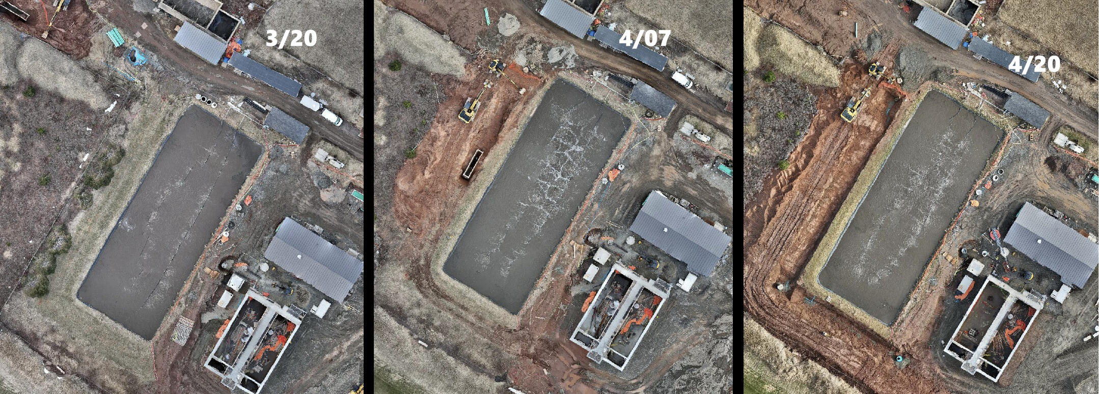
AEGIS delivers structured aerial site assessment and inspection services that support informed decision-making across construction oversight, environmental review, asset management, land use planning, and development activities. Our RPAS operations provide safe, efficient access to remote, elevated, or operationally constrained areas, improving inspection coverage while minimizing disruption to active sites.We collect high-resolution, geolocated, and time-stamped visual and thermal data using repeatable flight methodologies and controlled capture parameters. This produces consistent datasets across site visits, enabling reliable change detection, accurate condition assessment, progress verification, and early identification of emerging issues.The result is not just a record, but a practical decision-support tool. Defensible, auditable aerial data allows engineers, managers, and regulators to evaluate conditions objectively, prioritize actions, reduce uncertainty, and justify critical decisions with documented evidence. Date-specific imagery supports planning, risk management, compliance, and long-term asset stewardship, while strengthening accountability and liability management.
Deliverables
All deliverables are site-specific and tailored to the client’s operational and documentation needs. Outputs are provided in standardized, clearly labeled digital formats suitable for reporting, record-keeping, and long-term reference, and can be delivered in commonly used mapping, modeling, and imagery file types to ensure compatibility with engineering, GIS, and asset management workflows.
High-Resolution Visual Imagery & Videography
Geolocated, time-stamped aerial imagery safely documenting overall site conditions and spatial context. Telephoto imagery is used to capture high-resolution detail of critical points of interest—such as defects, material interfaces, or key components—without requiring close physical access or disruption to ongoing operations.
Thermal Imagery and Analysis
Radiometric thermal imagery captures surface temperature variation that is not visible in standard photography. It is used to identify temperature anomalies associated with heat loss, moisture intrusion, electrical components, or material inconsistencies across buildings, infrastructure, and operational assets.All thermal data is collected and interpreted by a certified sUAS Thermographer operator and provided as a decision-support tool for maintenance planning, targeted investigation, and ongoing condition monitoring.
Orthomosaic Mapping
High-resolution interactive orthomosaic maps produced for accurate site documentation, progress tracking, and comparison against design drawings, prior site mapping, or historical satellite imagery. Orthomosaics support large scale reliable distance and area measurements, along with general volumetric estimates.
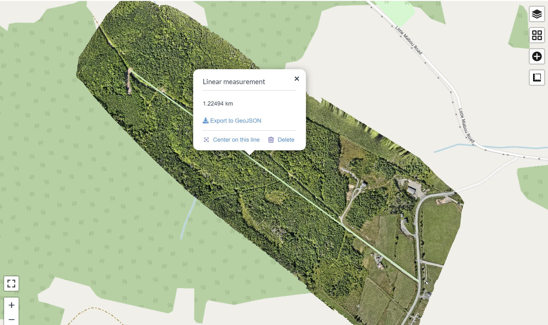
Each orthomosaic is delivered with a PDF photogrammetry quality report, including ground sampling distance, reprojection error, control accuracy, and processing metrics
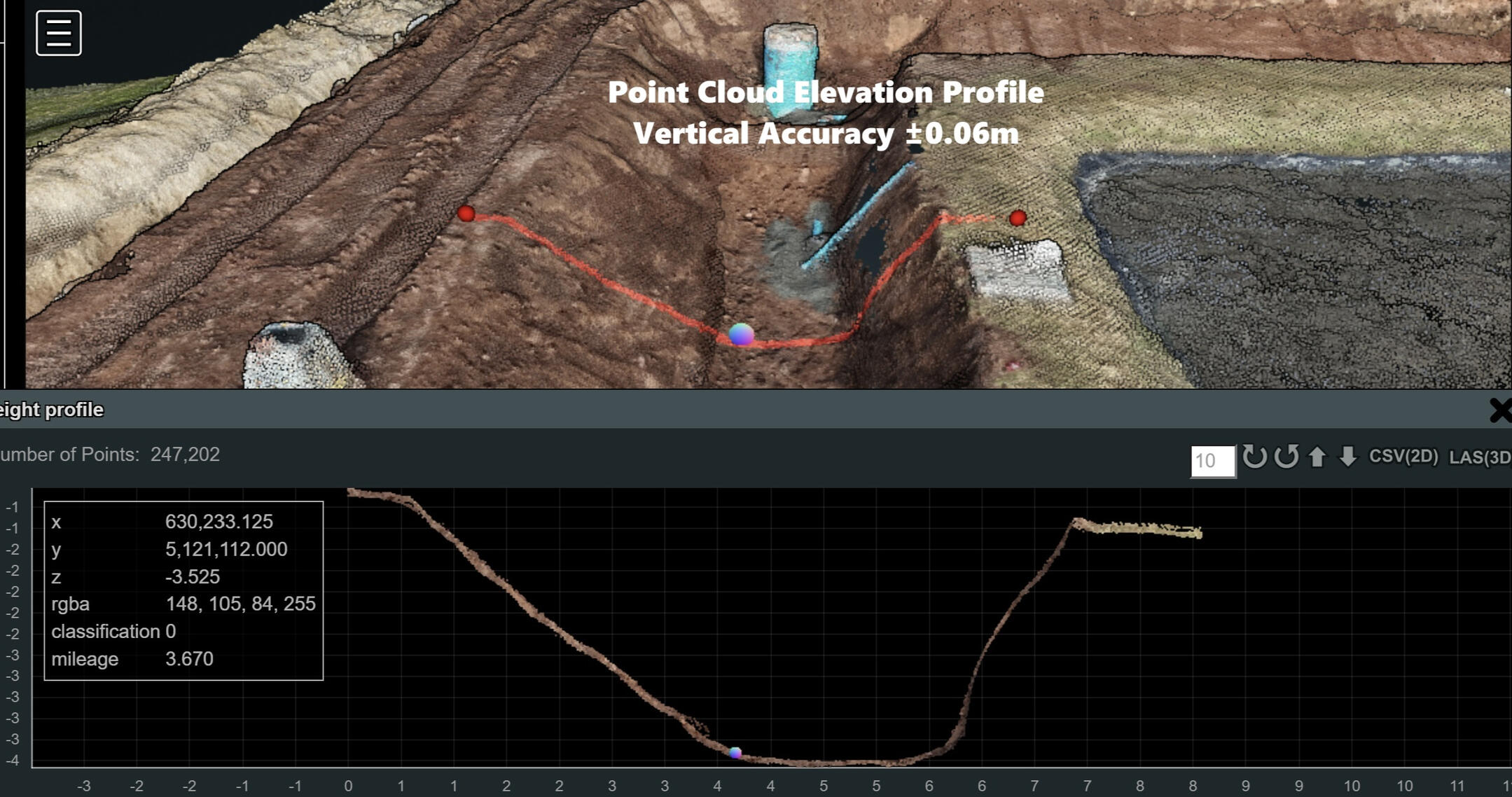
3D Site or Structure Models
Interactive 3D models generated to support clear visual reference, spatial understanding, and volumetric analysis of sites or structures. Models support distance, height, area, and volume calculations, elevation profiles, and clear visualization of complex site conditions.
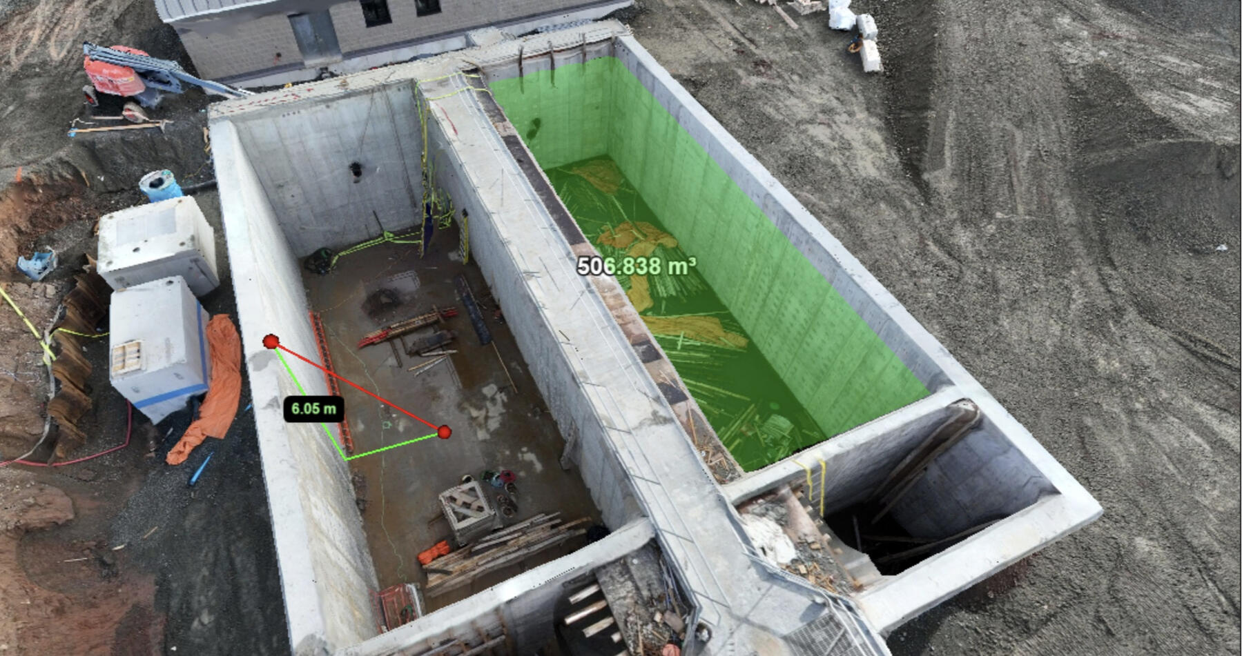
Each 3D rendering includes a PDF photogrammetry quality report outlining reconstruction quality, alignment statistics and point cloud density.
Orthomosaics and 3D site models can be generated using RTK-enabled workflows and industry-standard processing methods, when the project requires higher positional accuracy. Accuracy levels are matched to the intended use of the data and discussed during project scoping, ensuring the right balance between precision, efficiency, and cost.Deliverables are designed to support site inspection, documentation, planning, and informed decision-making. They are not intended to replace legal land surveys or engineered design services.
Ortho-Mosaic Mapping
Ortho-mosaic maps can be thought of as a current, high-resolution version of Google Earth, created specifically for your site and your project. Unlike satellite imagery, ortho-mosaics capture site conditions at a specific point in time and are corrected for scale and distortion, allowing distances, areas, and features to be viewed and measured reliably.These maps provide a clear, plan-view record of a site that is well suited for construction planning, site documentation, progress tracking, and general analysis. Because all imagery is geolocated and time-stamped, ortho-mosaics serve as a consistent visual reference that can be revisited as site conditions change.At AEGIS, ortho-mosaic mapping workflows may incorporate Real Time Kinematics (RTK) positioning to improve spatial consistency and repeatability where required. Mapping accuracy and level of detail are defined in advance and matched to the needs of the project. Before work begins, intended use, accuracy expectations, and deliverables are discussed and agreed upon with the client to ensure the data collected is appropriate for its purpose.Deliverables are provided in common, industry-standard formats compatible with widely used mapping, CAD, and visualization softwares, making ortho-mosaic maps easy to view, share, and integrate into existing workflows.
3D Modeling
3D models provide a clear, up-to-date visual record of a site or structure, capturing real-world conditions at a specific point in time. Created from geolocated aerial imagery, these models allow users to view and understand a site in three dimensions rather than relying on flat drawings or isolated photographs.The models support measurement and review, making them useful for construction planning, progress tracking, earthworks, and general site analysis. Volumes, distances, and elevations can be reviewed directly within the model, helping teams better understand site conditions without repeated site visits.A key advantage of 3D models is their use as an interactive inspection and documentation tool. Users can move freely around the model to examine features from multiple angles and, where needed, reference the underlying aerial imagery for closer review. This provides a clear, traceable record of site conditions that can be revisited later for reporting, review, or dispute resolution.
Mapping accuracy and level of detail are defined in advance and matched to the needs of the project. Before work begins, accuracy requirements, intended use, and deliverables are discussed and agreed upon with the client to ensure the data collected is appropriate for its purpose.All 3D modeling projects include a corresponding ortho-mosaic map, providing both a plan-view overview and full 3D context for reference, analysis, and documentation.
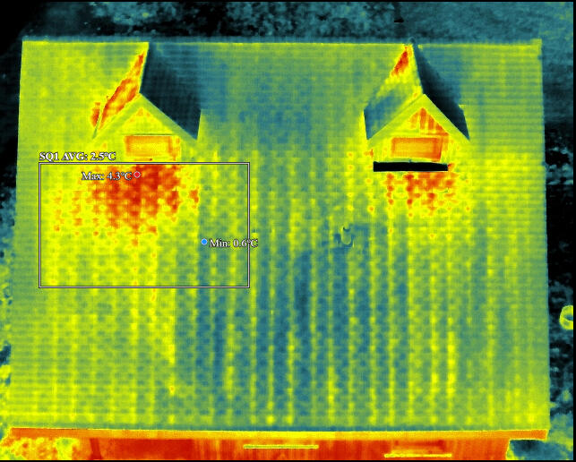
Thermal Inspection
AEGIS Drone Services provides professional thermal drone inspections using enterprise-grade RPAS platforms and radiometric thermal sensors. Thermal imaging captures temperature differences that are not visible to the naked eye, supporting building envelope assessment, solar panel inspection, livestock rescue operations, and infrastructure investigation. These services allow us to assess inaccessible areas efficiently, safely, and with documented results suitable for maintenance planning and decision-making.
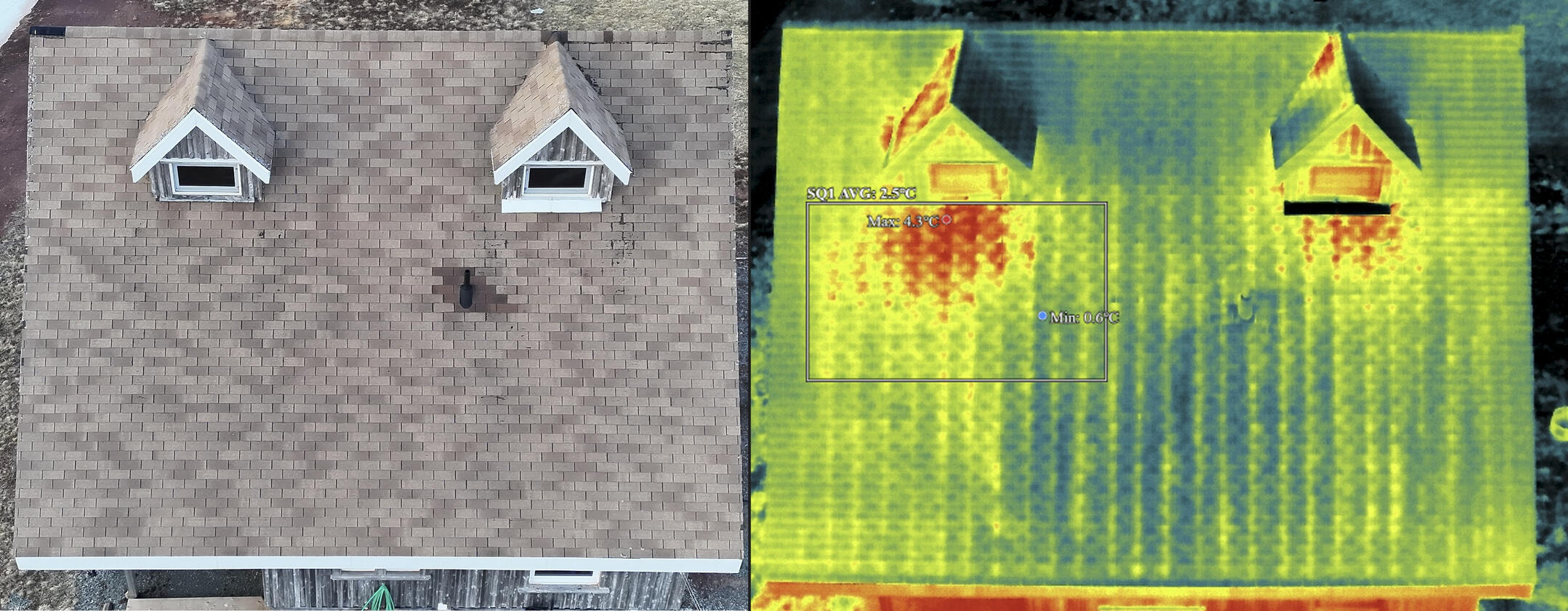
Heat signature below windows is a likely sign of water infiltration into the roofing membrane.
Thermal imaging identifies surface temperature anomalies that may indicate underlying conditions. Results are influenced by environmental factors and operating conditions at the time of inspection, and findings are used to support further assessment rather than serve as a standalone diagnosis.
UAV Certification & Drone Training
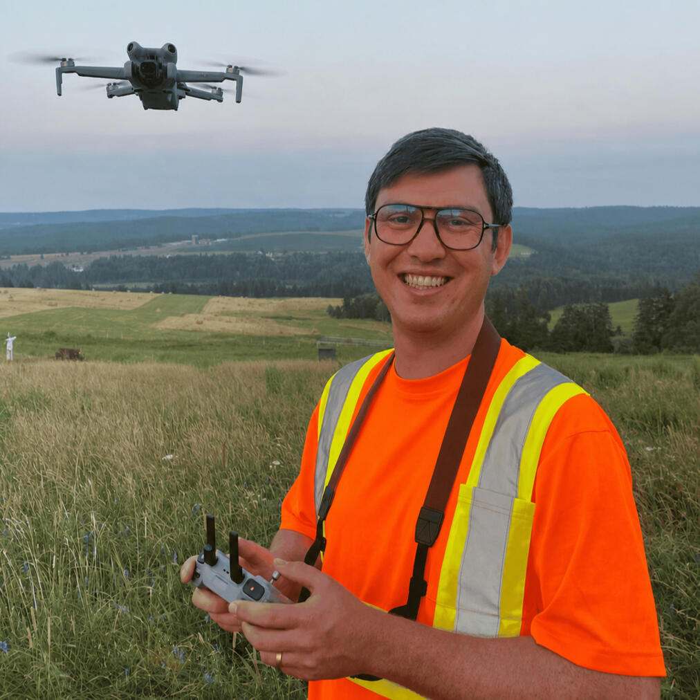
AEGIS Drone Services provides Unmanned Aerial Vehicle (UAV) certification support and practical drone training for individuals and organizations operating in regulated or industrial environments. Training is led by Matthew Hobden, Founder and Accountable Executive of AEGIS, a Transport Canada certified Advanced Drone Operator and Flight Reviewer. Services include Transport Canada flight reviews for UAV operators pursuing Advanced certification, as well as operational and equipment-specific training focused on safe, efficient, and compliant real-world use.
Flight Review Eligibility & Prerequisites
Flight reviews are conducted in accordance with Transport Canada requirements. UAV operators must meet applicable eligibility criteria prior to booking, which include:• Proof of completion of Transport Canadas Advanced Drone Operator exam
• Access to a compliant RPAS suitable for the flight review
• Demonstrated familiarity with applicable operating rules, procedures and equipment.

Aerial Solutions
Have a project you want to bring to life?AEGIS offers professional aerial photography and 4K video to support marketing, communications, and creative projects.From real estate and property visuals to landscape imagery, branded content, and custom storytelling, we work with businesses, organizations, and individuals to deliver high-quality aerial visuals suited for websites, social media, and promotional use.
RPAS Consulting
AEGIS Drone Services Inc. helps organizations build professional drone programs that are both regulatorily compliant and operationally effective. We combine deep knowledge of Transport Canada’s Remotely Piloted Aircraft Systems (RPAS) framework with hands-on, equipment-specific training that prepares teams to operate confidently in real-world environments.As of November 4, 2025, Canada introduced a clear, standardized regulatory framework governing professional commercial drone operations. For many organizations, this is the first time drone use has been treated as a formal aviation activity, with requirements that extend well beyond owning a drone or holding a pilot certificate. Compliance now involves documented procedures, defined operational authority, formal risk management practices, and consistent, auditable execution in the field—foundations that, once properly established, allow organizations to deploy drone technology safely, efficiently, and at scale.AEGIS bridges that gap. We provide RPAS compliance and regulatory consulting alongside practical, mission-focused training tailored to your aircraft, sensors, operating environment, and staff experience. Our approach ensures that procedures are not only compliant on paper, but usable, defensible, and repeatable in the field.We support organizations with RPAS program design, Standard Operating Procedure (SOP) development, and implementation of Remotely Piloted Operator Certification (RPOC) for commercial drone operations. Services include preparation for Advanced pilot certification and Advanced pilot flight reviews, supported by practical, equipment-specific training. Teams leave with the knowledge to meet regulatory expectations and the confidence to operate safely and efficiently.Whether you are launching a new drone program or strengthening an existing one, AEGIS delivers integrated compliance and training solutions that reduce risk, improve consistency, and support long-term operational success.
Contact AEGIS Drone Services Inc. for specific inquiry and consultation.
About AEGIS
Site assessment. Actionable information. Defensible documentation.
AEGIS Drone Services provides professional RPAS-based site assessment, mapping, inspection, thermography, and documentation services for construction, infrastructure, municipal, environmental, and commercial projects across Nova Scotia.We help clients understand site conditions, document change over time, inspect difficult-to-access areas, and support decisions with clear aerial data. Deliverables may include high-resolution imagery, orthomosaic maps, 3D models, radiometric thermal imagery, inspection records, and supporting documentation.AEGIS combines industrial field experience, GIS-based thinking, and Transport Canada–compliant RPAS operations to provide practical information that clients can use for planning, reporting, maintenance, risk management, and project communication.
Frequently Asked Questions
Q: How much do drone services cost?
A: As a general reference point, AEGIS Drone Services offers a basic site visit and visual inspection starting at $249, intended for general documentation and site assessment. This service provides professional aerial imagery suitable for reporting, decision making, and project communication.More involved projects—such as orthomosaic mapping, 3D models, thermal inspections, or multi-flight missions—are quoted individually based on project requirements, reflecting the additional flight planning, regulatory considerations, data collection and processing complexity, and travel distance to the site.All services are quoted on a project-by-project basis to ensure pricing accurately reflects the scope of work and the value delivered.
Q: Are you Transport Canada certified to fly drones commercially?
A: Yes. All drone operations are conducted in full compliance with Transport Canada’s RPAS regulations, and are specifically aligned with the November 4, 2025 regulatory framework that governs professional commercial drone operations in Canada.AEGIS Drone Services operates under a Transport Canada Remotely Piloted Aircraft Operator Certificate (RPOC). This certification confirms that company operations are conducted using approved procedures, safety planning, and oversight, providing clients with assurance that flights are managed to a professional standard suitable for commercial work.Regulatory compliance is reviewed with clients before work begins, ensuring that all operations are appropriate for the site, airspace, and project objectives.
Q: Can you fly in controlled airspace or near airports?
A: Yes, in many cases. Operations in controlled airspace require additional coordination and authorization.Each project is reviewed in advance to determine airspace restrictions, required approvals, and operational feasibility before any flights takes place.
Q: How does weather affect drone flights?
A: Weather directly impacts flight safety and data quality. Wind, precipitation, visibility, temperature, and lighting conditions are all evaluated before operations.If conditions are unsuitable, flights may be delayed or rescheduled to ensure safe operations and reliable results.
Q: Do you carry insurance for drone operations?
A: Yes. AEGIS Drone Services carries commercial aviation liability insurance appropriate for professional drone operations.Proof of insurance can be provided upon request and is suitable for construction, municipal, and commercial projects.
Q: What deliverables do clients receive from a drone project?
A: Deliverables are defined during project scoping and may include:• High-resolution aerial photos or video
• Orthomosaic maps
• 3D models
• Thermal imagery
• Telephoto Inspection images or video
• Supporting reports or documentationAll deliverables are provided in client-ready digital formats for review, reporting, or integration into existing workflows.Where helpful, orthomosaic maps can also be printed at large format (engineering-size) for on-site use, review meetings, or field markups. Large-format printing is available for an additional printing fee.
Q: What are drone maps, models, and imagery typically used for?
A: Drone data is commonly used for:• Site documentation and progress tracking
• Visual inspections and site condition assessments
• Planning, design support, and communication
• Asset management and record keeping
• General measurement and spatial understandingUse cases are discussed in advance to ensure the data collected supports the intended application.
Q: How accurate is drone mapping and measurement data?
A:Accuracy depends on project design, flight parameters, site conditions, and processing methods.Orthomosaics and 3D site models can be generated using RTK-enabled workflows and industry-standard processing methods, when the project requires higher positional accuracy. Accuracy levels are matched to the intended use of the data and discussed during project scoping, ensuring the right balance between precision, efficiency, and cost.
Q: Who owns the data, and how is it handled?
A: Unless otherwise agreed, clients retain ownership of all project data.All data is handled securely and confidentially, with storage practices that protect data integrity. Data is not shared or reused without client authorization.
Have a project-specific question? Contact us to discuss your site, project goals, and scope of work.
Contact Us
Don’t hesitate to reach out. All inquiries will receive a response within 48 hours.
Prefer to speak directly? Call (250)-619-1178
Thank You
You will receive a response in one to two business days.